MapServer is a powerful WMS server. However the configuration of vector data can be difficult
for those without time or experience.
for those without time or experience.
This is where tools such as MapManager come in.
They provide a simple editor that allows you to create a MapServer map interactively.
The downside is that tutorials are non-existent and you still need to know too much.
I have created a top level shapefile layer:
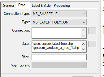
I am using OSM shapefile data (OSM data can’t be used directly).
I am now essentially ‘subclassing’ the ‘fclass’ attribute for each unique value (MapManagers
equivalent is Theme's).
equivalent is Theme's).
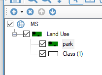
Right mouse on ‘Land Use’ allows you to create a new class.
So for ‘park’ the class setup is as follows:
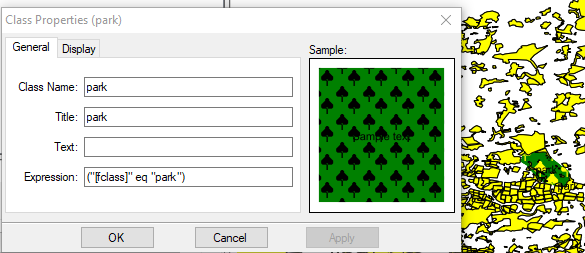
The trick to the subclassing is the expression line:
("[fclass]" eq "park")
This equates to the following in the map file:
EXPRESSION ("[fclass]" eq "park")
You can find out what attributes exist in a shapefile using the following command:
D:\Users\damian\Downloads\west-sussex-latest-free.shp>ogrinfo -so -al gis.osm_landuse_a_free_1.shp
INFO: Open of `gis.osm_landuse_a_free_1.shp'
using driver `ESRI Shapefile' successful.
Layer name: gis.osm_landuse_a_free_1
Geometry: Polygon
Feature Count: 11978
Extent: (-0.958257, 50.722778) - (0.048514, 51.187845)
Layer SRS WKT:
GEOGCS["GCS_WGS_1984",
DATUM["WGS_1984",
SPHEROID["WGS_84",6378137,298.257223563]],
PRIMEM["Greenwich",0],
UNIT["Degree",0.017453292519943295]]
osm_id: String (10.0)
code: Integer (4.0)
fclass: String (20.0)
name: String (100.0)
Comments
Post a Comment